|
China
 |
|
|
Currency
Renminbi (RMB)
Electric Plug Details
Two parallel flat blades
Electricity
220Volt, 50Hz
IDD City Code
10
IDD Country Code
995
Language
Putonghau (Mandarin)
Mobile System
GSM
Time Zone
GMT/UTC +8()
Useful Telephone
Emergencies 120
Police Dial 110
Fire & Ambulance 119 |
 |
 It is where the ancient people of the Gaochang city are buried. It is famous for its terracotta figurines and tomb paintings. The site is located approximately 40 kilometers away from Turpan city to the south of the Gaochang Ruins. The 10-square-kilometer-mound houses over 500 tombs.
The residents here varied from the high rank government officials, great generals to soldiers and civilians.
It served as graveyard of the citizens of Gaochang from 273 in the Western Jin Dynasty to 778 in the Tang Dynasty. The cemetery was separated by gravel based on family. Each tomb is entered via a slope of about 10 meters. The earth chamber is over 2 meters high and 4 meters wide, with a flat ceiling or a dome. The dead were placed on an earthen Kang or a simple wooden bed at the back of the chamber. They wore cotton or lime or silk clothes and had a wooden bar in hands. Their faces were covered by pieces of cloths. Around them lies models of pavilions, towers, horses, carts, parades, pens, ink and musical instruments or some food and fruits including grape, melons, dumplings, pancakes and so on. These things were prepared for the residents to enjoy in another world. The backs of some chambers were decorated paintings of figures, birds, animals, flowers and landscapes.
The majority in this graveyard are tombs of the Han People. Similar to other tombs in the Hexi(west of Yellow River) Corridor and Central China, tombs here were strictly arranged according to family generations. Usually the first tombs belonged to the oldest generations, then followed the older and so on.
80% of the corpses have formed mummies naturally because of the dry and windy climate in this area. The best preserved one is that of the General Zhangxiong of Gaochang States., 1.9 meters tall with well-preserved clothes and hair. The mummies excavated here can be compared with that of Egypt in quality. |
|

Goachang is the largest city ruin in west China. The site served as the economical and religious center of Asia is located 40 kilometers from the Turpan City, at the north bank of the Aiding Lake and to the south of the Flaming Mountain.
Gaochang was fertile and cultivated land and served as capital of three western states. From the historical documents and relics excavated in the region, historians are able to sketch the outline of this grand city. Gaochang's ideal location at the middle of the Turpan Depression and the city's well layout with high walls and deep moats made it a significant military fortress of the Western Region over years.
Founded in the Liang Dynasty, Gaochang became part of the Tang's territory from 640 under Emperor Taizong. The city saw frequent changes of dynasties in the following hundreds of years and it was fatally destroyed during wars launched by Mongols in 12th century. It was later abandoned and became a ruins.
The ruins cover around 2.2 million square meters, containing three parts: the outer and inner cities. The layout of the city is similar to that of Chang'an, capital of Tang Dynasty at that time. The outer wall is the only visible structure left today. Some parts are well-preserved. The wall is about 5.4 kilometers long and up to 11.5 meters high. The foundation of the wall is as thick as 12 meters which make the structure very solid and strong. At the southeast and southwest sections of the Outer city stands many temples ruins.
The Inner City is rectangle-shaped and stretches around 3,600 meters long. Architecture inside the Inner City mainly was temples and palaces. The palace complex is in the middle of the Inner City and share the north wall with the outer City. There were many high and grand building in the complex but they are all very difficult to discern in its current state. |
|
Karez Well System, Turpan
|
|
 Karez Well system is the pride of Turpan. It along with the Great Wall and Grand Beijing-Hangzhou Canal is regarded as the three most important achievements of ancient time.
Karez Wells created by the local people with their wit, dedication, blood and sweat crisscross the Turpan Depression like the vital and complicate blood vessel network. They created it out of necessity. Karaz irrigation system is vital to Turpan. It leads water to the most arid area and has created the vast oasis.
Xinjiang Province has over 1,600 Karez such systems with most of which are in Turpan. There are about 1,200 such systems in Turpan, some 850 of which are in active use.
??
Keraz systems are very elaborate irrigation systems. It make up of vertical wells, underground ditches, ground ditches and small reservoirs. The depth of the vertical wells and the space between them depends on their distance to the water source. Generally speaking, the ones in the upriver are deeper and more spaced than that in the lower reaches. Space between each vertical well in the up reaches ranges from 30 to 70 meters while in lower reaches it is about 10 to 20 meters. The deepest vertical well is over 90 meters. Karez Well system is usually 3 to 8 kilometers long with the longest one measuring up to 20 kilometers. The vertical wells are for ventilation and maintenance of the Karez. The underground ditches are connected with the surface ones to lead the water up to the ground.
Turpan's unique geographical and climate features explain that why Karez is built in Turpan in large numbers. Melted snow from the Tianshan Mountain is the water source of the Karez. During summer seasons, large amount of melted snow and rain water flow to the basin. But it quickly seeps into the ground and become underground streams due to the arid earth surface. Turpan is the hottest and driest place in China, Karez reduces evaporation and safe every drip of the previous water.
Karez Well system has a long history of over 2,000 years and it first appeared in the Han Dynasty. Although big water channels and reservoirs have been built in recent years, Karez Well Systems still play an important role in Turpan. |
|

Grape Valley is at the Northeast of Turpan city, some 10 kilometers away from it. It is a gully to the west of the Flaming Mountain. The valley runs 8 kilometers long, spans 0.6-2.0 kilometers wide. While the west side of the valley hangs sheer cliffs inside the valley is a forest of intertwined grape vines. Around the grape gardens towers vibrant poplar trees interspersed with a few flowers. Cottages and adobe houses are elaborately arranged on the slopes.
Turpan is nationally known for its grapes and dried raisins. The area began to plant grape as early as the Han Dynasty. When Zhangqian visited Western Region, over 2,000 years ago he found that people here has already grew grape and Zhang later introduce the grape into the inland provinces of China.
Under the twisted vines, set up many stalls selling kebabs, steaming noodles and dried raisins to travelers. In addition, the Wei Minority singing and dancing show is displayed here daily. Grape Valley is where most tourists stop for lunch during midday. |
|
Bezeklik Thousand Buddha Caves
|
|

Bezeklik Thousand Buddha Caves is at the Mutou Valley of the Flaming Mountain. There were originally hundreds of such caves. Unfortunately this area is highly exposed to natural erosion, which have severely damaged quite a few of them. Now there are 83 caves in good condition 50 percent of which are decorated with murals. The total murals find here reach up to 1,200 square meters.
The chiseling work began during the Gaochang Kingdom Period from 499 AD to 640 AD while large constructions were conducted from the 6th century to the 14th century for around 800 years.
The caves were palace temples of the Huihu Kingdom ( Huihu was the ancestor of today's Uygur) The features of the murals of that period were greatly influenced by that of the Tang Dynasty. They have precise designs, distinctive lines and bright colors. The figures are simple, with round heads, elongated ears and puppet-like segmented bodies which are boldly outlined. |
|

Sugong Ta, an elegant-shaped Muslim minaret, is located some 2 kilometers to the east of Turpan. It is very popular among local Muslims and visitors alike, throngs of whom come to visit it all year around.
It is the largest Muslim tower in Xinjiang region. The tower was built in 1778, over 200 years ago in honor of a great Turpan general -Emin Khoja and his great contribution to the unification of China.
The 44-meter high tower takes the shape of a huge column. It tapers from a big base with 10 meters in diameter to the Islamic dome. The structure is a combination of wood and bricks. 14 elongated windows were open at different levels and directions as a result of the need for the building to get enough sunshine and ventilate. The surface of the tower is carved with more than 15 different patterns such as waves, flowers and rhombuses. These elegant patterns are the highlights of the art of the Uygur.
|
|
 Jiaohe Town ruin is the best preserved town ruin in China. It is located about 10 kilometers away from Turpan city. The strip-shaped town was around 0.8 kilometers long and the widest point spanned about 300 meters. The town was surrounded by sheer cliffs, then two twisting 30-meter-deep rivers. That's why the town was so called for Jiaohe means twisting rivers in Chinese.
Hejiao's history can trace back to late Stone Age. Ancient residents built their homes in a lagoon island to protect against attack from wild animals and invasions from other tribes. They dug out dwelling caves out from the tough loess and chiseled passages to lead water from the rivers to the town. Visitors can still find some remnants of the simple tools including scraping tools,stone slates and colored pottery ware pieces on the ground close to the town ruin. These early residents belonged to the Gushi tribe, who was called Cheshi tribe in the subsequent dynasties. During the Warrior States Period, tribes on the south side of the Tainshan Mountain set up their own kingdoms successively. The area around Jiaohe was controlled by the Cheshi People who took advantage of the ideal geographical location of the region and made it their power seat. According to historical documents, Cheshi People live in tents and did farming. They raised cattle,. camels, ship and other livestock.
Jiaohe played an important military role in China's history. Jiaohe's vital location for trade and military made it especially vulnerable for invasion and attack. Dynasties in central China and nomadic tribes in north China fight bitterly for it. Jiaohe was recognizably territory of the Han Dynasty in 67 AD. The Han rulers set up administration office in the area to rule over the Kingdoms in the Western Region.
Jiaohe area was controlled by Tuque after the Han Dynasty. The great Yang Dynasty defeated the Tuque and took the region. Jiaohe county was later set up and it was under the jurisdiction of West Zhou. Jiaohe was afterward became the military and political center of the Western Region of the Tang Dynasty.
Turpan was gained by the Tubo tribe during the period from middle eight century to the nine century. The Tubo set up Jiaohe County here and it was one of the most important military towns. However, the government policy resulted in the decline of that town since ever.
Jiaohe was completely destroyed by wars in the 14th century. Evidences indicate that the places became a ruin as early as the Ming Dynasty.
In the ruin, there are 1389 residential house ruins, 53 Buddhism temples, 316 ancient wells and 34 alleys. The town was uniquely arranged, containing an above part and a underground part.
There were originally 3 gates to the town: the south, east and west gates. The South Gate was the mainly used for military purpose. The West Gate which was abandoned much earlier left very little evidence to piece together its original looks. But, historical documents display the dominant role it played. It was said that when the Han troops returned after defeated the Xiongnu, civilian and officials gathered at the gate celebrating victory over enemy.
The main street of Jiaohe Town ran from south to north, about 350 meters long and 10 meters wide. The street cut the town into two sections. The populous east section with dense buildings was the official area and the west section, characterized by sporadic dilapidated buildings was residential and workshop area.
The west section had 2,0000 square meter with main and attached buildings and squares. The grandest building complex in this part was the palaces of former Cheshi State. Crisscrossed streets and underground passages and gardens are visible in the ruin.
Buildings at the residential area are well preserved. The houses were mainly in cave-style created by digging into the ground. Each house is attached with a garden, inside which lied a deep well.
In the north side stood many Buddhism Temples. Jiaohe was once China's Buddhism center. Buddhism spread from Indian through the Western Region to inland provinces of China and it's was flourished at the Western Region on its way. Western Region thus renowned as the Second Hometown of Buddhism. |
|

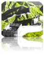
Flaming Mountain is at the north fringe of the Turpan Basin. It was called Red Rock Mountain for the dark red sandstone dominating the area. Many years of volcanic activity have formed the unique crisscrossing gullies and ravines. During mid-afternoon the heat becomes intense as the sun's rays are reflected off the red rocks, as though the hillsides are engulfed by tongues of fire, hence the name.
The mountain stretches across the Turpan Basin from east to north measuring 98 kilometers long, 9 kilometers wide. It located at an altitude of around 500 meters with the highest point of 821 meters close to Tuyugou.
Flaming Mountain was formed around a hundred million years ago. The whole mountain contains nothing more than these reddish slopes and gullies. At midday during summer time, the mountain looks like a huge flying red dragon setting off fires in the fiery sun and temperature can top 55 degree centigrade.
Flaming mountain is the hottest place in China and highest temperature sometimes climbs to 48 degree centigrade and temperature on the earth face occasionally reaches over 70 degree centigrade. According to the famed Chinese novel Journey to the West, when the Tang monk Xuanzang and his three reached this place, fires raged for hundreds of miles. One of his followers, the Monkey King extinguished the fire with a magical palm fan whisked from the throat of the ever-protective Iron Fan Princess.
The foot of the mountain offers a great contrast to the barren, lifeless mountain, where the Grape Gully, Peach Gully, Tuyu Gully are located. These gullies are lush cultivated areas with greenery, flowing rivers. When autumn comes, these regions feature sweet fruits and ripe melons. |
|

The canyon stretches from the Subeixi ancient village in the north to the entrance of the Maza village for around 8 kilometers long. It averages 1 kilometer in width. Inside the canyon stands the highest peak of the Flaming Mountain. The canyon splits the grand Flaming Mountain into two parts. It was the most mystical place in West China. Since 1900s, groups of explorers from the wolrd have thronged to this place and still nobody find any evidence on when the canyon was formed. However, one thing is obvious that Tuyugou canyon once served as an important pass on the ancient Silk Road.
Around the Canyon are numerous cultural heritage and historical sites. At the north side lie a vast grave yards of the ancient Gushi People, a tribe living in this area. The cemetery was so big that it is renowned as the second mausoleum of the Subashi State by archeologist. In the 1920s, a large number of dry bodies and valuable cultural relics are dug out here, many of which were later transferred to Xinjiang autonomous Museum and Turpan Museum. |
|

Aiding Lake is situated in the southern part of Turpan Basin in Northwest China's Xinjiang Uygur Autonomous Region, about 40 kilometers south of the city of Turpan. It is a salt lake with an area of 124 square kilometers. The lake is 155 meters below sea level -- the lowest place in China and the second lowest place in the world, next to only the Dead Sea (-391 meters) of Jordan.
Aiding Lake means Moon Lake in the Uygur language but few people seen the scene of the late water reflecting the moon light. It is so called simple because of natural beauty and tranquil environment.
Aiding Lake is an inland salty lake formed thousands of millions of years ago. More than 200 small rivers, brooks from the melted glaciers from Tianshan Mountain and other mountains empty themselves into the lake and serve as the water source of it.
The lake originally covered an area of 152 square kilometers but the far larger amount of vaporized water than the influx, as well as the large demand of water as a result of increase population has resulted in the dramatic decline of water level in recent years.
Contrasting to other lakes whose banks are fertile with lush vegetations, the area around the lake is the arid and wild Gebi. |
|
|
|


 back
back